|
|
|
In Fermoy, Ireland |


|
by Paudie McGrath
Gone but not entirely forgotten are the street and place names,
which were in use in Fermoy for almost 150 years until about 1922 when most of the names had
changed to names that mainly commemorate our Irish patriots. Fermoy in the old days was described as a market, garrison and post town, situated 23 miles N.E. of Cork
and 134 miles S.W. of
Dublin.
| |
Back in the early days of the last century if you went for a walk around the town of Fermoy, and started walking from the most northerly point of the town on the Dublin Road at the Pike Road junction, the very first place you would see is the Racecourse and its viewing stand which were on the Fitzgerald Camp playing field This was a very popular race and special trains arrived into Fermoy carrying huge crowds on race days. There were usually about six meetings a year held there. The remains of the concrete stand could still be found in the right hand corner of that field until very recently. There are three houses opposite Fitzgerald Camp and the address of these used to be and still is 'Racecourse View'. There was also a dog track in Fermoy back in those days. This was situated in Strawhall and was also a very popular place of entertainment for both locals and the military. Times, places and people continually change, and with this in mind I invite you to come on a trip with me back to the Fermoy of ‘times past’ when it really was a garrison and market town, placing particular emphasis on the old British street and place names. |
King’s Square, renamed Brian Boru Square; Queen’s Square, now known as Pearse Square; King’s Street, now MacCurtain Street; Prince’s Street,Victoria Terrace, Albert Place,Grubb’s Quay, now Ashe Quay; Grubb’s Hill,William Street, Bowling Green Street,Bridewell Hill, Artillery Quay and the Polo Grounds - these are some of the street names and squares, when Fermoy was a British Garrison town and predominately a market place for the people in the surrounding area. The British Military arrived in Fermoy about 1797 and had a continuous presence in the town until 1922. When the British left Fermoy in 1922, the Barracks and Military Hospital were burned to the ground during the period that was referred to as ‘The Trouble Times’. The actual burning took place in August 1923 and from that period onwards, British street names disappeared. |
 Military Cemetery |
 Fermoy Golf Club |
Fermoy Golf Club occupied the land on the right hand
side of the road beyond the Camp as you approach Fermoy from the Dublin side.
This stretched back to the quarry and to the
Fermoy/Mallow railway track. Golf in Fermoy started in
what was called the
Aerodrome. It then moved to the Sandpit in
Duntaheen Road and moved back again to the
Aerodrome fields in the late 1920’s.
This remained their home until 1970 when they moved to
Corrin. Across the main road from the Golf Club is
St.Josephs Square, which
was built in the early 1950’s.
As you walked towards the town the first prominent building you would see would be the magnificent
British Army hospital, which was situated inside the high
stonewall opposite the present-day Dairygold store on the Dublin Road. There are still
iron rings embedded in that wall, which were used to tie up the ponies and donkeys during that period.
|
|
"This Hospital was said to be one of the most modern hospitals in Europe.
One of the many historic occasions associated with the hospital was the fact that
Richard Kent, mortally wounded at Bawnard House in May 1916, and who died in the
Military Hospital on the 4th May 1916, lay in repose in the Hospital before his
final removal and burial. The burial took place after dark in compliance with
Military restrictions".
You would then continue southwards passing the goods entrance to the Railway Station and then under the railway-bridge, which crossed the main road. This bridge carried the main railway line from Cork to Rosslare, which was the property of the Great Southern and Western Railway Company. The Railway Station was opened in 1860. |
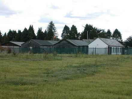 Fitzgerald Camp |
 Kent Memorial on Fermoy Bridge |
This
bridge was considered the
gateway into Fermoy. It crossed over the main road just about where the two garages,
Shell and Statoil, are presently situated on the
Dublin Road. The Railway line ran along outside the
Pitch and Putt wall where the
Beechfield Road is now. On the left hand side of the road there
was a very substantial property called
Beechfield House which was located
in the field where Beechfield Estate now stands. This property was
demolished in the 1960’s.
As you start your walk down towards Oliver Plunkett Hillwhich was then
Barrack Hill, you’d find
Albert Place
on your right, now named McDermott Place.
The Albert Place nameplate is still on the wall of Shinnick’s Supermarket over the Post Box.
|
|
The forage yard was across the road where Wolfe Tone Park was built in 1912.
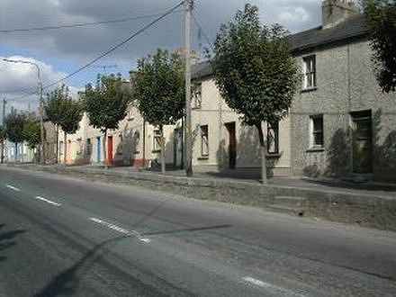
South of Wolfe Tone Park lies Casement Row, which
was then called Factory Row. No one seems to know what factory the name refers to but the old
people used to say that there was an ammunition factory somewhere in that area.
The next street on the right is Bridget Street. This was a very busy street and was called West Barrack Street. This street had many homes, seven pubs and a guesthouse and also had a number of service type businesses. |
Factory Row |
